New panoramic view of campus

Panoramic Street View imagery of Stetson University is now available in Google Maps.
Take a virtual look at Google Maps’ new panoramic imagery of Stetson University’s DeLand campus, beginning today. The university partnered with Google Maps for the project, which features high-definition, 360-degree images and offers viewers access to campus locations not previously available in online maps.
The digital, street-level photographs of Stetson are helpful to new students who may still be learning their way around campus, and for future Hatters who want to start feeling at home in the college environment. Parents can stay in touch with their sons’ and daughters’ home-away-from-home, and alumni can keep the college experience at their fingertips.
“This imagery enriches the interactive experience by offering more options for exploring the beauty of Stetson’s historic campus,” said Gregory Carroll, vice president for Marketing at Stetson University. “We’re pleased at the way Google Maps’ Street View feature showcases the university facilities and natural surroundings that contribute to Stetson University’s distinctiveness and significance.”
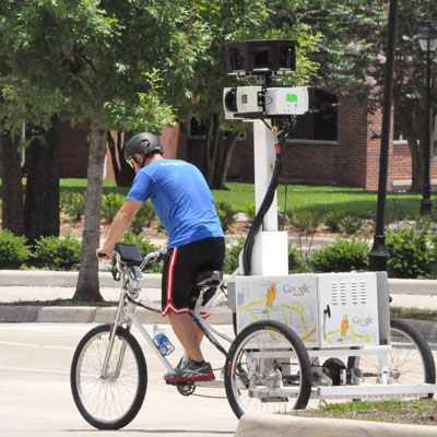
Google visited DeLand last spring to capture the panoramic imagery, mounting Street View cameras on a three-wheeled pedicab called a trike and riding through campus. The Street View car and trike generated excitement on campus and around town, and resulted in media coverage including West Volusia Beacon article on May 18, 2012.
Stetson is one of several universities worldwide participating in the Street View Partner Program. Panoramic imagery of other campuses in the United States, and in Canada, Brazil, Spain, France, UK, Netherlands, Israel, Japan and Taiwan are also being unveiled today.
The Street View imagery of Stetson is available in Google Maps, Google Earth and Google Maps for Mobile, allowing a global audience to share in the beauty of historic buildings and Florida landscaping that Hatters enjoy every day.
Simply search for Stetson University on Google Maps map, and either zoom in to the lowest level, or drag the orange “Pegman” icon on the left-hand side of the map onto an area of the campus outlined in blue. From there, people can visually navigate around campus through these street-level photographs, move up and down pathways, and explore in 360 degrees.


